
Agriculture provides raw materials, fuel, fibers, and food to humanity. However, this crucial role must be carried out in the face of climate change and environmental sustainability challenges, all while accommodating a growing population and ensuring the continued viability of agricultural activities to sustain livelihoods.
The application of remote sensing in agriculture plays a crucial role in the evolution of farming practices, helping to address various challenges by providing real-time information about crop status at different scales throughout the growing season.
Remote sensing in agriculture
Remote sensing and agriculture go hand in hand. The basic operation of this technology, using UAVs (Unmanned Aerial Vehicles), satellites, and other platforms, is similar across the board. Energy, in the form of light, travels from the sun to Earth. Just like ocean waves, light waves travel in a pattern – the distance between the peak of one wave to the peak of the next is known as wavelength. The energy emitted by the sun is electromagnetic energy, which forms part of the electromagnetic spectrum. The wavelengths used for agricultural applications occupy a small portion of this spectrum
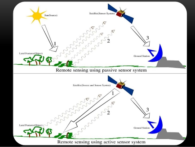
When electromagnetic energy interacts with plants during hyperspectral remote sensing in agriculture, one of three things can happen: the energy will be reflected, absorbed, or transmitted. The outcome depends on both the wavelength of the energy and the specific characteristics of the plant. Remote sensing technology can detect the reflected, absorbed, and transmitted energy.
The interplay between these three interactions creates the plant’s spectral signature, which is unique to different species. By analysing these spectral signatures, remote sensing in agriculture helps identify stressed areas by comparing the signatures of healthy plants
Advantages of remote sensing in agriculture
Agriculture is one of the most significant land-use activities worldwide. In addition to altering land cover, agriculture has a profound impact on the sustainable development of the social economy, the carbon cycle, climate change, ecosystem services, and food security. There are various types of remote sensing used in agriculture. Understanding the location, area, status, and transformation of farmlands is essential for assessing how human activities affect the lithosphere, hydrosphere, and biosphere. Moreover, remote sensing can aid in the formulation of sustainable agricultural development policies and the simulation of the carbon-nitrogen cycle. Therefore, understanding remote sensing and its applications in agriculture is crucial
Applications of remote sensing in agriculture
Remote sensing technology has found numerous applications in fields such as forestry, geology, surveying, and photography. However, its most significant impact has been in agriculture. The use of remote sensing in agriculture has proven to be highly beneficial, with various applications that include, but are not limited to, the following.
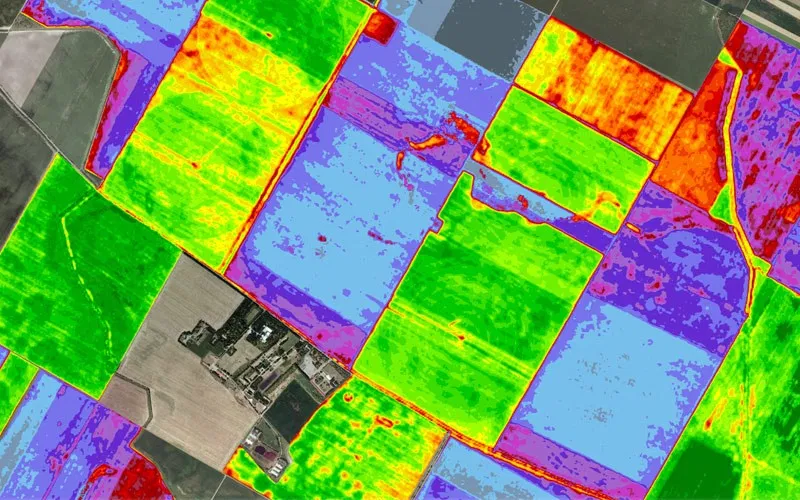
1. Observing and monitoring crops
A critical role of remote sensing in agriculture is monitoring crop health. Optical (VIR) sensing allows farmers to see beyond visible wavelengths, such as infrared, which are highly sensitive to crop vigor, damage, and stress. Recent advancements in this technology enable farmers to observe their fields in real time and make timely crop management decisions. Additionally, remote sensing helps identify crops affected by conditions such as weather patterns, pests, and other stress factors.
2. Observing soil conditions
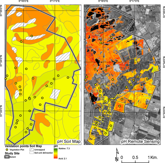
For precision agriculture, monitoring soil conditions is essential. Key soil parameters that help optimise crop management include soil organic matter (SOM), soil texture, pH levels, moisture content, and more. Remote sensing technology in agriculture also provides valuable data on canopy health, growth stages, yield, biomass, and vegetative density. To investigate changes in crop growth patterns, it is important to understand the link between crop performance and soil conditions.
3. Monitoring Water Conditions
With population growth and rising food demand, irrigated land is expected to double by 2050. This expansion will reduce water availability, contribute to climate change, and trigger other environmental shifts. Therefore, monitoring and assessing agricultural water resources is crucial for sustainable food security and development. Remote sensing in precision farming provides accurate and timely information on water bodies, irrigated cropland, and crop and soil water status across various scales.
4. Predicting Weather Conditions
Climate and weather data systems are crucial for informed crop management decisions and irrigation scheduling. Additionally, this data can help in preparing for natural disasters. Remote sensing in precision farming provides spatial coverage to accurately predict upcoming weather conditions. With this data, farmers can better anticipate crop needs and reduce unnecessary costs..
5. Observing Air Quality
Different crops thrive under varying air conditions—some withstand strong winds, while others require calmer environments. Remote sensing in plant protection enables the monitoring of air conditions in specific locations, helping farmers anticipate changes and take necessary precautions against unfavourable weather.
6. Precision Farming
In recent decades, advancements in farming techniques have helped agriculture keep pace with the growing demand for food. Precision farming and crop mapping with remote sensing enhance crop yields while minimising environmental strain. Modern technologies like AI and the Internet of Things (IoT) further support these efforts, making agriculture more efficient and sustainable.
7. Monitoring and Predicting Climate Changes
Remote sensing has significantly advanced our understanding of climate change by quantifying changes in the oceans, land, and atmosphere over time. While previous technologies could detect weather and climate shifts, they lacked the precision of modern remote sensing. In agriculture, weather plays a crucial role in determining crop yields, making this technology an invaluable tool for accurate climate change predictions and improved farming decisions.
Explore More in Agricultural Remote Sensing
As remote sensing continues to transform agriculture, advanced imaging technologies play a key role in optimising crop monitoring and resource management. Our CubeSat and SmallSat cameras provide high-resolution imaging for a wide range of applications, from agriculture to environmental monitoring and beyond. Notably, our Dragoneye camera – used on the EOS SAT mission – has a proven heritage in agricultural remote sensing, delivering precise data for crop health assessment and land monitoring. Additionally, we offer EOS SAT data, empowering farmers and researchers to make more informed decisions and support sustainable agriculture.