
Remote Sensing Satellite Imagery: What Are its Uses?
What is the best satellite imagery? Remote sensing is the process of monitoring the physical characteristics of a location by measuring the emitted and reflected radiation at a distance (via aircraft or satellite). These bodies are fitted with unique cameras that shoot pictures, unlike ordinary photos. Remote sensing satellite imagery is more specialized and provides more data than simple images.
These cameras capture images of large areas, which allow you to see more than when you are merely standing on the ground. Some of these cameras are also fitted with sonar systems that create images of the ocean without traveling to the bottom of the ocean. The cameras can also make images of temperature changes in the oceans.
Different Applications of Remote Sensing Satellite Imagery Data
Remote sensing satellites revolve around the planet in established intervals. These bodies record and provide data in real-time. With the obtained data, you can analyze the historical background and the current state of things.
These findings provide the base for further scientific research and facilitate people’s daily activities in various aspects of life, both in theory and practicality. While there are already many satellite imagery applications and remote sensing data, there is still much to discover.
Here are some well-known and practical uses of satellite imagery and data.
Improving Agriculture via Remote Sensing Satellite Imagery
As we all know, agriculture forms the basis for the entire world’s food supply. Climate changes, weather extremes, water availability, and soil conditions can prove serious challenges for farmers. Space-based technology is of great value to agricultural policymakers, food manufacturers, agronomists, and farmers that wish to enhance productivity and profits. Solid research is currently on-going.
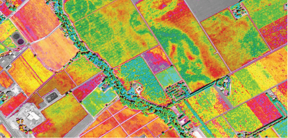
One use of satellite imagery is to understand critical data to monitor and understand crop development, drought, snow cover, and soil. Rainfall assessments from these satellites can help farmers set the timing for irrigation and/or seeding—the data can also provide accurate predictions about a region’s agricultural output.
Saving Wildlife
Different types of technologies today have greatly expanded opportunities to collect and analyze data for wildlife monitoring and assessment; satellite remote sensing is one of them. With these high-resolution imageries, researchers and scientists have increased geospatial data to provide accurate statistics for tracking endangered species in remote areas, mapping habitats, and monitoring migration. This has greatly helped in conservation and management activities.
The remote sensing imagery technology has dramatically helped conservationists and animal experts. Wildlife is constantly threatened by poaching, deforestation, and habitat loss. Many species have been categorized as endangered, and these imageries will help maintain a track and monitor wildlife.
Assessing Risk
One of the essential tools for a regional planner is remote sensing the area. Apart from helping in the general planning process, remote sensing satellite images can also prove valuable for mapping different types of disasters. The introduction of high-resolution imagery has opened new possibilities in the process of risk estimation, mitigation, and management.
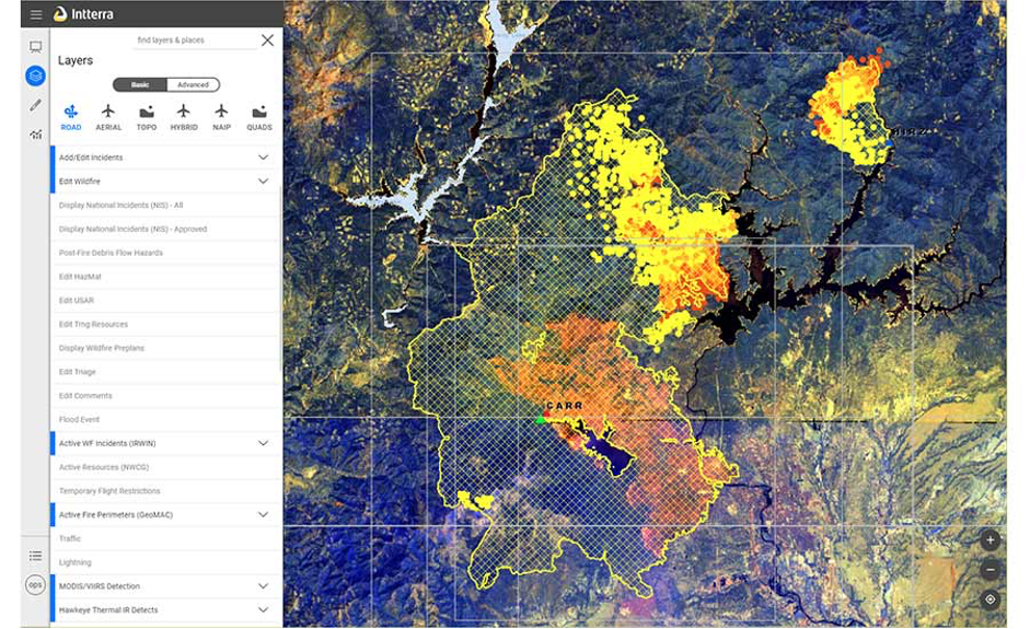
Obtaining data of a wide area in a short time has become useful for both effective damage estimation as well as emergency management. Additionally, the images of the immediate aftermath of disasters like volcanic eruptions, tsunamis, fires, floods, hurricanes, and earthquakes have been distributed globally. Identifying potential natural disasters can help save a lot of lives.
Studying Urban Geography
Remote sensing imagery has been hailed as one of the most effective technologies for the job when it comes to monitoring and mapping environmental changes and urban growth. One of the most important advantages is the synoptic and repetitive coverage that can help study different metropolitan areas. It helps create a base for urban environmental impact assessment, monitor urban growth, detect the urban change, land cover distribution, and land use.
With this satellite imagery in remote sensing, you will understand some crucial components of typical urban ecosystems and interactions within entire urban environments. If incorporated with GIS (Geographic Information System), remote sensing technology will provide better opportunities. Changes over some time will be detected with ease.
Managing Disaster Recovery
As mentioned above, remote sensing technology can help a lot in disaster management. It has been successfully used to assist risk reduction initiatives by identifying hazard zones associated with active faults, coastal inundation, and flood plains. By measuring the magnitude of the actual events and the location, hazard models can be verified.
Meteorologists mostly use imagery to provide warnings of potentially deadly weather conditions. The technology provides emergency responders and the public with information to make immediate decisions. Additionally, the remote sensing satellite image processing data can also be shared on the Internet to be viewed worldwide.
Image Classification For Urban Expansion
Mapping urban forms at local and regional scales is essential for studying urban expansion’s influence on the surrounding environment and the overall ecosystem. Remote sensing imagery is used to monitor and detect urban areas that spring up due to incessant urbanization. This is important because its influence can be manifested in urban planning, socio-economic problems, etc. As compared to other conventional mapping methods, remote sensing imagery provides certain advantages like coverage, efficiency, and convenience.
Solar Panel Energy Output Optimization
As of now, we are sitting at the crossroads between fossil fuels and renewable energy and increasingly worrying about the environment’s safety. New types of remote sensing satellite imagery techniques and tools are developed to aid and monitor energy efficiency more efficiently. To do this, you need the data to be reliable and updated.
One of the most important tools used is remote sensing imagery. Even in the most pressing challenges, this data can help understand and monitor the energy infrastructure. Apart from crucially analyzing the markets, it can also reduce potentially damaging events.
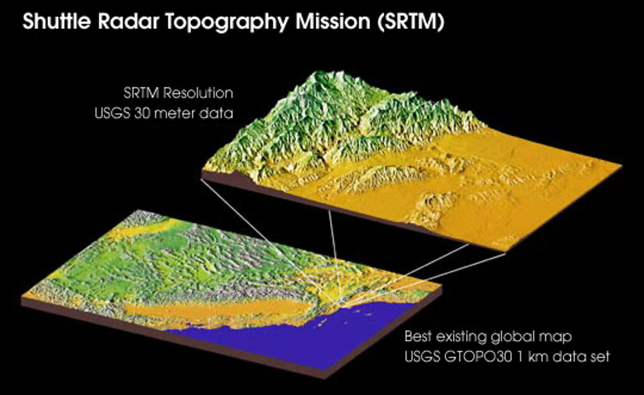
Generating and Studying Earth’s Surface Elevation Via Shuttle Radar Topography Mission
The SRTM, or the Shuttle Radar Topography Mission, is an international project of NASA and NIMA (National Imagery and Mapping Agency). This project has been set to obtain digital elevation imagery and generate a digital topographic database of the Earth. This satellite imagery and remote sensingdata is mostly used for geographic information systems and can be downloaded via the Internet. Overall, this data can help you understand the elevations in any particular area.
Observing The Growth of Urban Population
Population growth is a dynamic phenomenon that can affect the natural environment. It has given rise to many different questions, all asking the same thing – how do you address development while minimizing the environmental impact? To do this, you need to have adequate data and knowledge about population dynamics to create appropriate plans and policies.
Final Thoughts
Remote sensing satellite imagery has been considered a time-efficient way to analyze population, especially in larger cities/townships. This method has been used for many years now and will provide you with reliable data. The imagery will give you an idea about the population in an area to plan according to the available data.
What are your thoughts on the future of this technology?