
Agriculture provides raw materials, fuel, fibers, and food to humanity. This role needs to be fulfilled within climate change and environmental sustainability, combined with the expanding population while maintaining agricultural activities’ viability to sustain livelihoods.
The application of remote sensing in agriculture can help the evolution of agricultural practices face different types of challenges by providing information related to crop status at different scales all through the season.
Remote sensing in agriculture
Remote sensing and agriculture go hand in hand. The basic working of this technology with UAVs, satellites, and other platforms is almost the same. Energy, in the form of light, will travel from the sun to the Earth. Light waves travel virtually like ocean waves – the distance between the peak of one wave to the peak of the next is known as wavelength. The energy emitted from the sun is known as electromagnetic energy and is part of the electromagnetic spectrum. The wavelengths that are used for agricultural applications cover a small amount of the electromagnetic spectrum.
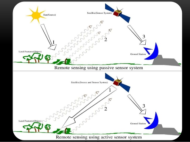
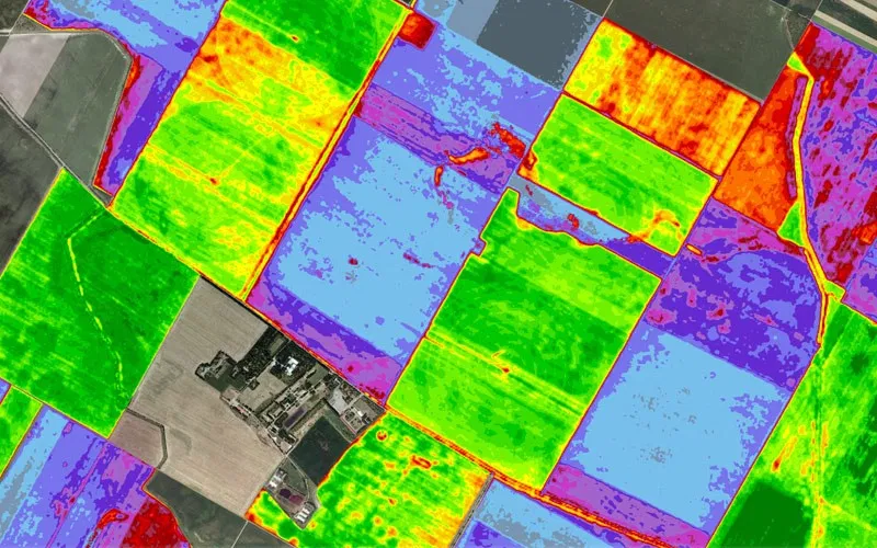
When electromagnetic energy hits the plants during hyperspectral remote sensing in agriculture, one of three things can occur. The energy will be reflected, absorbed, or transmitted, depending on the wavelength of the energy and the characteristics of the plant itself. The reflected, absorbed, and transmitted energy can be detected by remote sensing technology.
The relationship between the three occurrences determines the spectral signature of the plants. This signature is unique to different plant species. Remote sensing farming helps identify stressed areas by determining the spectral signatures of plants that are healthy.
Advantages of remote sensing in agriculture
Agriculture is one of the most significant land-use activities around the world. Apart from changing the land cover, agriculture also profoundly impacts the sustainable development of the social economy, carbon cycle, climate change, ecosystem services, food security, etc. There are types of remote sensing in agriculture. The location, area, status, and conversion information of farmlands are vital if you want to understand how human activities will affect the lithosphere, hydrosphere, and biosphere. Additionally, you can also formulate sustainable agricultural development policies and study the simulation of the carbon-nitrogen cycle. Hence, understanding remote sensing and its application in agriculture are vital.
Applications of remote sensing in agriculture
Remote sensing technology has found numerous applications in fields like forestry, geology, surveying, and photography. However, the use of remote sensing in agriculture is where it has been found most useful. Some of the many applications of agriculture and remote sensing include the following.
1. Observing and monitoring crops
A critical role of remote sensing in agriculture is monitoring the health of crops. Optical (VIR) sensing allows one to see beyond visible wavelengths, like infrared; in this case, the wavelengths are very sensitive to crop vigor, damage, and stress. Recent advances in this technology have allowed farmers to observe their fields and make timely crop management decisions. Crop identification using remote sensing also helps identify crops affected by conditions related to weather, pests, etc.
2. Observing soil conditions
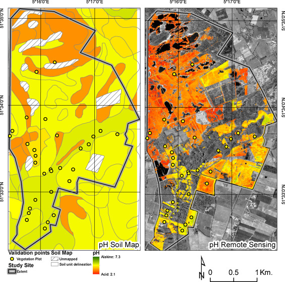
For precision agriculture, monitoring the soil is essential. Some critical soil parameters to optimize crop management include soil organic matter (SOM), soil texture, soil pH level, moisture content, etc. Remote sensing technology in agriculture will also provide canopy health, growth stage, yield, biomass, and vegetative density. If you want to investigate the crop growth pattern changes, you need to emphasize the link between crop performance and soil conditions.
3. Monitoring water conditions
Due to population growth and food demand, it is expected that irrigated lands will double by 2050. It will decrease water availability, contribute to climate change, and cause other environmental changes. Hence, monitoring and assessing agricultural water resources are critical to achieving sustainable food security and development. Remote sensing in precision farming has successfully provided accurate and timely information like water bodies, irrigated cropland, crop and soil water status, and various scales.
4. Predicting weather conditions
Climate and weather data systems are essential if you want to make crop management decisions and schedule irrigation. Additionally, this data can also help you prepare against natural disasters. This application of remote sensing in precision farming has provided spatial coverage to predict upcoming weather conditions successfully. With this data’s help, you will be provided better predictions of crop needs and help cut down unwanted costs.
5. Observing air quality
Different types of crops thrive in different air conditions. Some may do well against windy air conditions, while others are more suited for calmer environments. Remote sensing in plant protectionhas allowed us to determine air conditions in specific locations. This data can help you predict upcoming air conditions to take the necessary precautions in case of unfavorable weather conditions.
6. Precision farming
The introduction of new farming techniques in the last few decades has helped agriculture keep pace with the increasing population’s food demand. Precision farming and crop mapping using remote sensing aim to increase the yield of the crops and minimize strain on the natural environment. Modern technologies like AI or the Internet of Things have proved to be useful in this aspect. Remote sensing uses in agriculture have also been used to increase the productivity of the crops.
7. Monitoring and predicting climate changes
The remote sensing concept and application in agriculture has provided a lot of advances when it comes to an understanding of climatic changes by quantifying the temporal states of the oceans, land, and atmosphere. While technologies could detect weather and climatic changes, there were not as precise as this one. When it comes to farming and agriculture, weather plays an important role and will determine the yield results. Hence, this technology has proved to be a valuable tool for making accurate climate change predictions.